14 November, 2020

Flood! Flood! Flood!


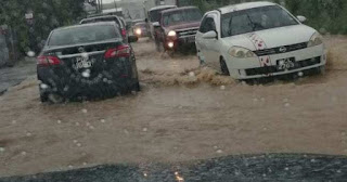
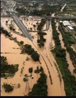
    In October 2018 residents in communities all across Trinidad and Tobago were adversely affected by massive flooding which followed continuous rainfall on Friday 19th and intermittent rainfall on Saturday 20th. Rivers in Caroni, Diego Martin and Maraval breached their banks. Several communities were evacuated as homes and vehicles were flooded and many areas were inaccessible. 

    Flooding along the Caroni River caused the submersion of a major part of the Uriah Butler Highway .The south-bound lane of this highway was temporarily closed to vehicular traffic. The north-bound lane was temporarily used for two-way traffic, permitting only large SUVs and heavy-T vehicles. Flight services out of Piarco International Airport were temporarily disrupted.
    Although flooding is the result of rainfall or storm surge the effects of flooding are becoming increasingly dire with loses amounting to millions of dollars. The flooding that occurred in October  2018 alone affected 150 000 residents and incurred damages to the tune of US$ 3.7 million or TT$25 million.

    Why does flooding occur and why is it so devastating on the population? Well firstly the more devastating effects of floods occur near coastal areas, around natural water courses and areas on the Caroni Plain, Naparima Plain and Navet Plain. Unfortunately residences, urban centres, roads and other infrastructure are established in these areas putting them at risk from flood damage.

Flooding can be attributed to:


Prolonged rainfall that saturates the soil causing increased surface runoff leading to rivers overflowing their banks into the neighbouring flood plains


Intense/Heavy rainfall. This causes water droplets to bounce off the soil and flow over the surface increasing surface runoff.


Relief. When rain falls, the surface runoff can move very quickly from mountainous or hilly areas to low lying areas making these low lying areas more prone to flooding. This is typical of communities along the East-West corridor, the Western peninsular and those at the foot of the central and southern ranges.


Deforestation and poor land use practices. The lack of vegetation encourages water to flow over the surface rather than infiltrate into the soil thus increasing surface runoff. Deforestation, Slash and burn agriculture, over-cultivation and over-grazing are also responsible for depleting vegetation resulting in flooding of low lying areas.

Deforestation in the Northern Range

Flooding at Trincity Mall


Urbanization and illegal settlement (squatters) Urbanization replaces the soil with an impermeable surface that results in increased run-off and flash flooding. Squatter settlements remove the natural vegetation and create heavy surface runoff where they are located causing floods.

 Port of Spain waterfront


Squatter community


Improper Waste Disposal. Dumping of garbage into water courses and improper disposal of garbage which eventually enters watercourses cause blockages to the free flow of watercourses resulting in floods.


ODPM receives disaster management equipment


    Disaster Management received a boost on 10th November, 2020 with the donation of disaster management equipment from the Ambassador of the United States of America to Trinidad and Tobago, His Excellency Joseph Mondello.


    At the handover ceremony at the ODPM's Alternate National Emergency Operations Centre in Mausica, the Minister of National Security, the Honourable Stewart Young, received 2 Jeep Wranglers, 96 hand-cranked radios, 18 Samsung Tablets and 60 first aid kits to assist with the country's disaster management efforts.


    Also in attendance at the handover ceremony were the Minister of Rural Development and Local Government Senator the Honourable  Kazim Hosein, Permanent Secretary of the Ministry of Rural Development and Local Government Ms. Desdra Bascombe, Acting Permanent Secretary in the Ministry of National Security Mr. Gary Joseph, Chief Executive Officer of the Office of Disaster Preparedness and Management Major General (Retired) Rodney Smart and Chief Military Liaison Officer U.S. Embassy to Trinidad and Tobago Colonel Claudia Carrizales.

    The Jeep Wranglers will improve the ODPMs capability to conduct field operations during emergency and disaster situations. The ODPM will also oversee the distribution of the other equipment to the Disaster Management Units of the Ministry of Rural Development and Local Government to enhance their coordination, communication  and overall management of persons in their areas affected by disasters.


04 November, 2020

Early Warning Color Code Meanings

    Thus far for 2020, the Trinidad & Tobago Meteorological Service has issued no less than 15 Adverse Weather Yellow Alerts for Trinidad and Tobago.

A typical Adverse Weather Alert from the MET Office looks like this:


    What do these warnings mean and how should we respond to these warnings?

    Well, a Yellow Alert is part of the MET Office Hydrometeorological (Hydro-Met) Warning System that alerts the public of potential hazards and recommends the necessary action to be taken to protect life and property.

    Hydrometeorological hazards are of atmospheric, hydrological or oceanographic origin. Examples are hurricanes,  floods, flash floods; drought; heatwaves and cold spells; and coastal storm surges.

    Therefore early warning alerts can be issued for rough seas, riverine flooding and even for the effects localised thunderstorms.

    These alerts are published in advance of the expected hazard via traditional media, social media, Short Message Service (SMS) and even via community loud hailer systems as in the case in south-west Tobago.


The Early Warning Colour Code System employed by the MET Office is shown below:


Click on the chart above for further information.

Featured Post

Have a laugh


Most Viewed