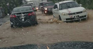
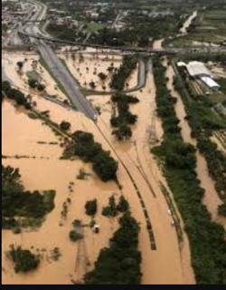
In October 2018 residents in communities all across Trinidad and Tobago were adversely affected by massive flooding which followed continuous rainfall on Friday 19th and intermittent rainfall on Saturday 20th. Rivers in Caroni, Diego Martin and Maraval breached their banks. Several communities were evacuated as homes and vehicles were flooded and many areas were inaccessible.
Flooding along the Caroni River caused the submersion of a major part of the Uriah Butler Highway .The south-bound lane of this highway was temporarily closed to vehicular traffic. The north-bound lane was temporarily used for two-way traffic, permitting only large SUVs and heavy-T vehicles. Flight services out of Piarco International Airport were temporarily disrupted.
Although flooding is the result of rainfall or storm surge the effects of flooding are becoming increasingly dire with loses amounting to millions of dollars. The flooding that occurred in October 2018 alone affected 150 000 residents and incurred damages to the tune of US$ 3.7 million or TT$25 million.
Why does flooding occur and why is it so devastating on the population? Well firstly the more devastating effects of floods occur near coastal areas, around natural water courses and areas on the Caroni Plain, Naparima Plain and Navet Plain. Unfortunately residences, urban centres, roads and other infrastructure are established in these areas putting them at risk from flood damage.
Flooding can be attributed to:
Prolonged rainfall that saturates the soil causing increased surface runoff leading to rivers overflowing their banks into the neighbouring flood plains
Intense/Heavy rainfall. This causes water droplets to bounce off the soil and flow over the surface increasing surface runoff.
Relief. When rain falls, the surface runoff can move very quickly from mountainous or hilly areas to low lying areas making these low lying areas more prone to flooding. This is typical of communities along the East-West corridor, the Western peninsular and those at the foot of the central and southern ranges.
Deforestation and poor land use practices. The lack of vegetation encourages water to flow over the surface rather than infiltrate into the soil thus increasing surface runoff. Deforestation, Slash and burn agriculture, over-cultivation and over-grazing are also responsible for depleting vegetation resulting in flooding of low lying areas.
Deforestation in the Northern Range
Urbanization and illegal settlement (squatters) Urbanization replaces the soil with an impermeable surface that results in increased run-off and flash flooding. Squatter settlements remove the natural vegetation and create heavy surface runoff where they are located causing floods.
Port of Spain waterfront
Squatter community
Improper Waste Disposal. Dumping of garbage into water courses and improper disposal of garbage which eventually enters watercourses cause blockages to the free flow of watercourses resulting in floods.


No comments:
Post a Comment