29 November, 2020

Who does it?

Disaster Management in Trinidad and Tobago is coordinated by the Office of Disaster Preparedness and Management (ODPM). It is executed by the Disaster Management Units of the Ministry of Rural Development and Rural Government in Trinidad and the Tobago Emergency Management Agency (TEMA) in Tobago.


In times of emergency the National Response Framework is followed based on the nature of the emergency as follows:

Level 1 


A level 1 emergency is a localized incident. Such incidents are within the capacity of the local government authorities and other first responder agencies within a Municipality, or the Tobago Emergency Management Agency in the case of Tobago. The first responder agencies may include the Trinidad and Tobago Police Service (TTPS), the Trinidad and Tobago Fire Service (TTFS) and the Health Services, as necessary. At Level 1, the Emergency Operations Centre of the Municipal Corporation or TEMA will be activated as needed to coordinate the Regional, Borough or City response.


Level 2


At Level 2, the emergency or disaster event usually affects two or more municipal regions/Tobago, or while confined to one municipality, may be of a very serious nature (that is, have the potential for significant loss of life or damage to property, environment or economy). In such instances, the response can be dealt with using municipal and national resources.


If it is perceived that a Level 1 incident has the potential to escalate to a Level 2 event, the ODPM’s National Emergency Operations Centre (NEOC) would be notified and become partially activated. This activation would facilitate the closer monitoring of events and initiate preparation for response should the Level 1 response become overwhelmed.


At Level 2, greater resources would be required for damage assessment, search and rescue, security/ crowd control, relief supply distribution, etc., depending on the type of incident. The Trinidad and Tobago Defence Force (TTDF) usually becomes involved at this level.


Level 3


At Level 3, should the national resources become overwhelmed, the President will declare a national emergency. In such a scenario, the ODPM, through the Ministries of National Security, Foreign Affairs and Finance, will coordinate the acquisition of regional and international aid assistance.


Saharan Dust - Friend or Foe


When we hear about Saharan Dust we automatically think about the health issues and the constant cleaning up until the plume passes. However, it appears that this natural phenomenon is having a more noticeable impact on our lives.


As recent as June 2020, Trinidad and Tobago experienced the highest concentration of saharan dust in recent history. Air Quality levels were reduced to HAZADOUS with calls the reduced outdoor activity and persons with respiratory challenges to take extra precautions:


    You may be surprised to know that despite it being a major hazard to human health, the Saharan dust feeds life itself and disrupts the formation of hurricanes and thunderstorms.

    Saharan dust embarks on a more than 10,000 km journey to do more than create runny noses, itchy eyes and sore throats. Saharan dust is transported across the Atlantic Ocean to South America and beyond to the Caribbean Sea and is the largest transport of dust on the planet. Dust clouds from the Sahara Desert are often so big they can be seen from space.


    There are two main causes of Saharan dust transport, depending on the time of year. Harmattan Winds bring mild to moderate outbreaks across Trinidad and Tobago from November to the middle of March.

    Thunderstorms across Central and Western Africa being mild to severe outbreaks across Trinidad and Tobago between April and November, with peak outbreaks occurring from June through August.


Here are some of the benefits and hazards of Saharan dust:


Benefits:


  • Replenishes the Amazon Rainforest with much needed phosphorus.


  • It is a significant contributor of iron to marine algae. Phytoplankton in the Caribbean and along the southeastern U.S. coast feeds on this iron as well. It allows these organisms to thrive and produce a significant amount of oxygen.

  • It can also affect the formation of clouds as the layer of air in which Saharan dust is transported across the Atlantic is quite dry, suppressing cloud development. This dry air lay (Saharan Air Layer) also suppresses and hinders the development of tropical cyclones.

  • With increased dust in the atmosphere, increased scattering of light occurs at sunset. This allows for more colorful sunsets.


Hazards


  • High concentrations of dust with a diameter of fewer than 2.5 micrometers have been correlated with increases in emergency room admissions for respiratory and cardiovascular disease in North America, Asia, and Europe. The primary health concern associated with Saharan dust is particulate matter that can sidestep the lungs’ natural defenses can contribute to cardiovascular problems as well as respiratory diseases such as asthma, especially in children and the elderly.


  • The dust particles also serve as a vehicle for the transport of known asthma triggers such as biological materials, including bacteria, viruses, fungal spores, and pollen. It has also been shown to transport various pollutants such as metals and pesticides. Dry skin and cracked lips are also typical symptoms of dense Saharan dust.

  • Dust in our atmosphere ultimately causes hazy skies. Depending on the concentration, these hazy skies can significantly reduce visibility at airports, on the roadways, and on shipping lanes.


  • Saharan dust has several implications with regards to the weather.

    • The dust can reflect or block sunlight, causing lower than usual temperatures on the surface. However, this effect is only observed when concentrations are very unhealthy to hazardous.

    • It can also affect the formation of clouds suppressing the development of tropical cyclones. The negative side of this is rising ocean temperatures, bleaching corals and impacting predominant ocean currents which as a number of knock-on effects. Additionally, tropical cyclones can attribute a significant amount of rainfall for areas in which freshwater access is limited.

    • As the Saharan Air Layer is a well-mixed layer of dry air between 5,000 ft and 15,000 ft, this provides conditions to be favorable for higher instability and convective wind gusts at the surface in strong thunderstorms.

    • The dust mixes with the rainfall, and when it lands on the surface, it becomes a layer of dust and mud when the dust is particularly thick.

  • Pathogenic bacteria feed on the dust nutrients and create bacteria blooms which play a role in many diseased ocean organisms. Filter-feeding shellfish accumulate Vibrio parahaemolyticus and Vibrio vulnificus in their meat. This causes the majority of seafood-related sickness and death in the U.S. Other Vibrio species are known to be associated with diseased coral that is already facing so many other environmental stressors Vibrio disease and mortality have even placed an economic strain on the fishing and shrimp farming industries.

14 November, 2020

Flood! Flood! Flood!


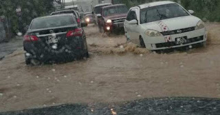
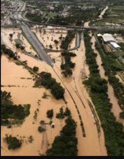
    In October 2018 residents in communities all across Trinidad and Tobago were adversely affected by massive flooding which followed continuous rainfall on Friday 19th and intermittent rainfall on Saturday 20th. Rivers in Caroni, Diego Martin and Maraval breached their banks. Several communities were evacuated as homes and vehicles were flooded and many areas were inaccessible. 

    Flooding along the Caroni River caused the submersion of a major part of the Uriah Butler Highway .The south-bound lane of this highway was temporarily closed to vehicular traffic. The north-bound lane was temporarily used for two-way traffic, permitting only large SUVs and heavy-T vehicles. Flight services out of Piarco International Airport were temporarily disrupted.
    Although flooding is the result of rainfall or storm surge the effects of flooding are becoming increasingly dire with loses amounting to millions of dollars. The flooding that occurred in October  2018 alone affected 150 000 residents and incurred damages to the tune of US$ 3.7 million or TT$25 million.

    Why does flooding occur and why is it so devastating on the population? Well firstly the more devastating effects of floods occur near coastal areas, around natural water courses and areas on the Caroni Plain, Naparima Plain and Navet Plain. Unfortunately residences, urban centres, roads and other infrastructure are established in these areas putting them at risk from flood damage.

Flooding can be attributed to:


Prolonged rainfall that saturates the soil causing increased surface runoff leading to rivers overflowing their banks into the neighbouring flood plains


Intense/Heavy rainfall. This causes water droplets to bounce off the soil and flow over the surface increasing surface runoff.


Relief. When rain falls, the surface runoff can move very quickly from mountainous or hilly areas to low lying areas making these low lying areas more prone to flooding. This is typical of communities along the East-West corridor, the Western peninsular and those at the foot of the central and southern ranges.


Deforestation and poor land use practices. The lack of vegetation encourages water to flow over the surface rather than infiltrate into the soil thus increasing surface runoff. Deforestation, Slash and burn agriculture, over-cultivation and over-grazing are also responsible for depleting vegetation resulting in flooding of low lying areas.

Deforestation in the Northern Range

Flooding at Trincity Mall


Urbanization and illegal settlement (squatters) Urbanization replaces the soil with an impermeable surface that results in increased run-off and flash flooding. Squatter settlements remove the natural vegetation and create heavy surface runoff where they are located causing floods.

 Port of Spain waterfront


Squatter community


Improper Waste Disposal. Dumping of garbage into water courses and improper disposal of garbage which eventually enters watercourses cause blockages to the free flow of watercourses resulting in floods.


ODPM receives disaster management equipment


    Disaster Management received a boost on 10th November, 2020 with the donation of disaster management equipment from the Ambassador of the United States of America to Trinidad and Tobago, His Excellency Joseph Mondello.


    At the handover ceremony at the ODPM's Alternate National Emergency Operations Centre in Mausica, the Minister of National Security, the Honourable Stewart Young, received 2 Jeep Wranglers, 96 hand-cranked radios, 18 Samsung Tablets and 60 first aid kits to assist with the country's disaster management efforts.


    Also in attendance at the handover ceremony were the Minister of Rural Development and Local Government Senator the Honourable  Kazim Hosein, Permanent Secretary of the Ministry of Rural Development and Local Government Ms. Desdra Bascombe, Acting Permanent Secretary in the Ministry of National Security Mr. Gary Joseph, Chief Executive Officer of the Office of Disaster Preparedness and Management Major General (Retired) Rodney Smart and Chief Military Liaison Officer U.S. Embassy to Trinidad and Tobago Colonel Claudia Carrizales.

    The Jeep Wranglers will improve the ODPMs capability to conduct field operations during emergency and disaster situations. The ODPM will also oversee the distribution of the other equipment to the Disaster Management Units of the Ministry of Rural Development and Local Government to enhance their coordination, communication  and overall management of persons in their areas affected by disasters.


04 November, 2020

Early Warning Color Code Meanings

    Thus far for 2020, the Trinidad & Tobago Meteorological Service has issued no less than 15 Adverse Weather Yellow Alerts for Trinidad and Tobago.

A typical Adverse Weather Alert from the MET Office looks like this:


    What do these warnings mean and how should we respond to these warnings?

    Well, a Yellow Alert is part of the MET Office Hydrometeorological (Hydro-Met) Warning System that alerts the public of potential hazards and recommends the necessary action to be taken to protect life and property.

    Hydrometeorological hazards are of atmospheric, hydrological or oceanographic origin. Examples are hurricanes,  floods, flash floods; drought; heatwaves and cold spells; and coastal storm surges.

    Therefore early warning alerts can be issued for rough seas, riverine flooding and even for the effects localised thunderstorms.

    These alerts are published in advance of the expected hazard via traditional media, social media, Short Message Service (SMS) and even via community loud hailer systems as in the case in south-west Tobago.


The Early Warning Colour Code System employed by the MET Office is shown below:


Click on the chart above for further information.

Featured Post

Have a laugh


Most Viewed